Update 2: Other sources talking about what is wrong with this map: solomonia.com, giyus.org, Jeffrey Goldberg in the Atlantic, Dvar Dea, zionism-israel.com and frontpagemag.com. also here.
(update: I added some updates about more reasons for the settlements as well as more about the size of israel, and a note about the british rule (with some images))
Apologies to the regular readers of this blog.
This is a political post, which I don’t usually do. I live in Israel. I love the fact that technology brings people together, and I have several online friends from countries considered enemies of or hostile to israel (syria, iran, lebanon).
With the recent conflicts between Israel and Palestinians in Gaza, You’ve probably seen this map being thrown around in various forums.
It depicts what seems to be a loss of land that was previously Palestinian. It looks pretty horrible without context, I know.As an israeli and as someone who really dislikes dis-information, I though I’d give my point of view, based on what the real facts .
I’m writing this so that I can point my friends and those who ask to a place where there is more context and info about this map, and why, even though it may be georgraphically correct, it is a distortion of reality to take it out of context.
A good source of history information about the conflict
a site doesn’t take sides, that has a more or less accurate information about the dispute can be found here.
OK, let’s talk about the maps from left to right (chronological order):
Map 1: 1946
_thumb_V86nSg.png) The map is NOT graphically correct. Several things are not accurate. First – the british had ruled israel. this was not arab land or jewish land. jews and arabs were living in british occupation. Another thing that needs to be said is that the bottom half of the map was unpopulated – it is a desert part in israel, and even today, it has less than 10% of the population living there because of the conditions. so it should not be green or white. it was largely empty.
The map is NOT graphically correct. Several things are not accurate. First – the british had ruled israel. this was not arab land or jewish land. jews and arabs were living in british occupation. Another thing that needs to be said is that the bottom half of the map was unpopulated – it is a desert part in israel, and even today, it has less than 10% of the population living there because of the conditions. so it should not be green or white. it was largely empty.
The arab population in israel was larger than the jewish population, and they were both growing at a large rate.There was a large influx of jews coming in(most of whom were fleeing the increasing persecution in Europe). There was lots of killing and massacres against the jews until the UN decided to partition the land (as seen on map 2).
Map 2:
_thumb_yiU8Vw.png) The UN decided what the division would be(israel got most of the uninhebited, desert part). arabs got the right part, and lots of the top and parts of the left. For context – the right side of the map borders with Jordan, which means the UN declared the green right part to actually be jordanian terrotory. the top part id bordering with syria and lebanon. the bottom part borders with egypt.
The UN decided what the division would be(israel got most of the uninhebited, desert part). arabs got the right part, and lots of the top and parts of the left. For context – the right side of the map borders with Jordan, which means the UN declared the green right part to actually be jordanian terrotory. the top part id bordering with syria and lebanon. the bottom part borders with egypt.
map 3:
_thumb_S9jeFQ.png) The important thing to remember here is that the arabs did not accept the UN decision and instead began to wage war against the israelis (who wanted to accept it). During this war the israelies had won, and had pushed the arabs back into what is now seen in map 3 (second from the right). Remember, this was war and the green zones were attaching the white ones. so green was smaller at the end of the war.
The important thing to remember here is that the arabs did not accept the UN decision and instead began to wage war against the israelis (who wanted to accept it). During this war the israelies had won, and had pushed the arabs back into what is now seen in map 3 (second from the right). Remember, this was war and the green zones were attaching the white ones. so green was smaller at the end of the war.
in essence, map 2 never came into existence. except in the minds of the UN.
that’s how it roughly stayed until 67.
map 4:
_thumb_Wb4Gpw.png) so how did we get from map 3 to map 4?
so how did we get from map 3 to map 4?
in 67, Egypt decided to declare war on Israel (the bottom gray in the map is the start of egypt. They essentially closed all the bottom part of israel and parts which are not seen on this map.
Jordan and Syria (to the right and to the top of israel) quickly joined in the war, and israel was now attacked from 3 sides. yes. that includes in inner green part that was actually attacking israel from almost within it.
Israel gained victory in that war, pushing back jordan, syria and egypt into what will now look closer to map no. 4 (most right).
the settlement problem
After Israel had won, it could have chosen to do many things – for example negotiate with jordan and leave the places won over to something like the 67’ border. But it chose, for mostly security, ideological and religious reasons, to stay in those territories and start building settlements there. it built roads that divided the occupied land and basically did lots of things which today there is nothing really good to say about them (and is slowly trying to turn back the wheel on some of them). Still, the security aspect is the one that is the most relevant today. It keeps the other side farther away. if they were closer, their missiles could have easily hit 60% of israel, instead of 30% right now.
A hole we can’t get out of
a lot of what people have a problem with today is the fact that israel as a country supported and still supports parts of the settlements, which are not legal by international law. the reasons, again, are security,ideological and religion (promised land etc..). there is a great divide among the israeli people whether this should continue or not but the situation has now become too problematic to easily solve. Many also believe that the settlements are a security measure that helps to keep the missile attacks farther away from the cities.
for example, Israel had actually gotten fully out of part of the territories (gaza for example), but got back missilies and rockets (which is why we see the Israel coming back in – to stop this). there were many negotiations and many agreements that were broken or followed by both on a single side of the conflict, and many believe that there is no one to talk to on the other side.
many in israel believe that two states are the end result any way, (something like the 67 borders) but want to make sure that the other state will not try to destroy israel (as it had promised to do, with the backing of iran and syria) many times. a state next to you has to recognize that you have a right to exist, and not try to burn you.
Why we are in gaza now
Israel is in gaza now for the simple reason of stopping the rockets and achieving a ceasefire that will last for a long time. it has started with a 6 month quiet period in which over 400 rockets were fired on israel from gaza with no retaliation.
there is no denying that the human situation in gaza sucks. Israel tries to aid in allowing food shipments, money and international aid through passages, but at the end of the day, right now, it is trying to defend itself. nothing more, and nothing less. with force, yes. because nothing else before that has worked.
The size of israel
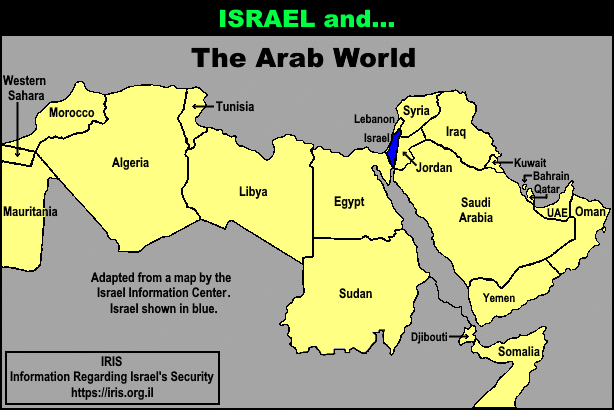
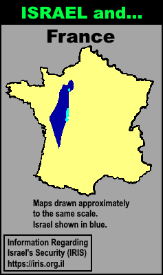
Israel is Tiny. Seriously. Much smaller than California, Norway or Argentina (see more places to compare). I can take my car and drive from north to south in about 6-8 hours of non stop driving. Compare israel to the size of its surrounding countries and you begin to see what “small and surrounded with enemies” feels like. Jews have literally nowhere else to go. Arabs have lots and lots. yet they insist that Israel be destroyed. And Israel still has to defend itself from many threats all around. and now, also from within.


There is a lot of mis and dis information running around the web right now. I hope that the facts can help sort things out. I hope that I had done justice to the facts.
Before writing this, I did some fact checking with a well known middle-east researcher before publishing this, and will update this post on problems or important comments.
